Phase 4: First Assessment &Feasibility Report
Design, Upgrading, and Preparation of Nine (9) Forestry Nurseries
Uzbekistan Resilient Landscapes Restoration Project (RESILAND CA)
Report Title:
G’allaorol State Forestry Enterprises – Qoravultepa Forest Section Nursery
First Assessment &Feasibility Report
Prepared by:
İsmail Belen
International Consultant – Forestry Nursery Design and Preparation
Date: 7 March 2026
1. Introduction, Context and Policy Framework 4
1.2 Alignment with the Uzbekistan–2030 Strategy and National Environmental Priorities 5
1.3 District Context: G’allaorol District, Jizzakh Region, Uzbekistan 6
1.3.1. Administrative Position 6
1.3.2. Distance to Major Centers 6
1.3.3. Surrounding Settlements 7
1.3.4 Landscape and Agro-Ecological Context 7
1.3.5 Strategic Position within the Regional Ecological Framework 7
1.3.6 Functional Implications for Nursery Development 8
1.4.2. Observation and Strategic Assessment 10
1.4.3 Water Resources and Hydrogeological Feasibility 11
1.4.4 Energy Infrastructure and Accessibility 13
1.4.5 Review of Technical Planning Documentation 14
1.5. Conclusion of First Assessment &Feasibility Report 14
Introduction
This First Assessment & Feasibility Report is prepared for G’allaorol State Forestry Enterprises – Qoravultepa Forest Section Nursery in line with the “Technical Disposition for the Design, Upgrading, and Preparation of Forest Nurseries in Uzbekistan (RESILAND CA Nursery Framework – RNF).”
The report has been developed as an integral component of the consultancy services under Contract No. LRP/IC/08, titled “International Consultant to Provide Technical Expertise for the Design, Upgrading, and Preparation of Nine (9) Forestry Nurseries.”
To this end, Mr. İsmail Belen, International Consultant, conducted an online assessment of the G’allaorol State Forestry Enterprises – Qoravultepa Forest Section Nursery, located in G’allaorol District of Jizzakh Region. The assessment and preparation of this First Assessment & Feasibility Report were carried out based on the information and documentation provided on 7 March 2026, in line with the contractual scope and in close cooperation with the authorities of the Agency for Expanding Forests and Green Areas and Combating Desertification (O‘rmonlar va Yashil Hududlarni Kengaytirish hamda Cho‘llanishga Qarshi Kurashish Agentligi).
1. Introduction, Context and Policy Framework
1.1. General Approach
The G’allaorol State Forestry Enterprise – Qoravultepa Forest Section Nursery is one of the nine (9) priority state forestry nurseries selected under the Uzbekistan Resilient Landscapes Restoration Project (RESILAND CA+).
As an existing and operational state forestry production unit, its inclusion among the nine target nurseries reflects its strategic importance in strengthening Uzbekistan’s capacity to supply consistent, high-quality, and climate-resilient planting material. Rather than representing a greenfield investment, the nursery constitutes an established production base whose modernization and capacity enhancement directly address one of the key structural constraints in the national restoration agenda: the insufficient and uneven availability of certified, site-adapted planting stock.
Under RESILAND CA+, nurseries are not treated as auxiliary facilities supporting isolated planting campaigns. Instead, they are conceived as core public production infrastructure forming the biological and operational backbone of large-scale landscape restoration. In this context, the G’allaorol State Forestry Enterprise – Qoravultepa Forest Section Nursery — hereafter referred to as the G’allaorol / Qoravultepa Nursery — contributes directly to the Project Development Objective (PDO) of bringing 280,000 hectares under sustainable landscape management through strengthened regional production capacity and reliable supply of planting material.
The nursery’s strategic role aligns with two core project components:
• Sub-component 1.1 – Strengthen Institutions and Policies
Serving as a practical implementation platform for standardizing nursery operations, improving production protocols, strengthening seed quality control and certification systems, and aligning operational practices with evolving forestry legislation and institutional reforms.
• Sub-component 2.1 – Enhance Tree-based Landscape Restoration and Management
Providing site-matched, drought-tolerant, and climate-resilient planting material required for agroforestry systems, reforestation, farmer-managed natural regeneration (FNR), protective forest belts, medicinal plant-based restoration models, and ecosystem service-oriented interventions.
Within the RESILAND CA+ results chain, the G’allaorol / Qoravultepa Nursery functions as:
• An operational production platform linking policy reform to field-level implementation;
• A risk-reduction mechanism minimizing plantation failure rates through improved quality control and species-site matching;
• A diversification hub integrating ecological restoration with economically valuable medicinal and aromatic plant production;
• A scalable regional production base supporting corridor-based and regionally differentiated landscape restoration strategies.
In strategic terms, the nursery represents a strengthened and policy-aligned biological asset within Uzbekistan’s long-term restoration framework, contributing to both ecological resilience and sustainable rural development.
1.2 Alignment with the Uzbekistan–2030 Strategy and National Environmental Priorities
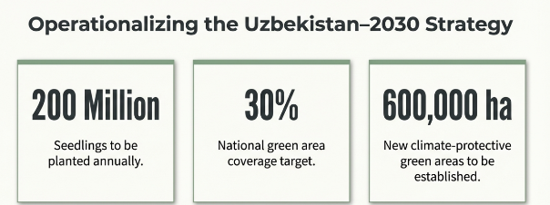
The Uzbekistan–2030 Strategy (Presidential Decree No. UP-158, 11 September 2023) establishes binding national targets under Articles 67–71 related to afforestation, erosion control, biodiversity conservation, climate adaptation, and restoration of degraded landscapes, including the Aral Sea region.
Key quantified national commitments include:
• Planting 200 million seedlings annually;
• Increasing green area coverage to 30%;
• Expanding forest area to 6.1 million hectares;
• Establishing 600,000 hectares of climate-protective green areas;
• Restoring 2.6 million hectares in the Aral Sea region;
• Increasing tree and shrub seed harvesting by 840 tonnes.
The achievement of these targets requires not only political commitment but also a permanent, technically robust, and regionally distributed nursery system capable of producing large volumes of diverse, climate-adapted, and quality-certified planting material.
Within this national framework, the G’allaorol State Forestry Enterprise – Qoravultepa Forest Section Nursery represents a strategically positioned operational asset in the Jizzakh Region. As an existing production unit with established plantation areas and structured management, the G’allaorol / Qoravultepa Nursery contributes directly to scaling up seedling output, diversifying species composition, and improving production reliability.
Strengthening the G’allaorol / Qoravultepa Nursery under RESILAND CA+ therefore supports the Uzbekistan–2030 Strategy by:
• Enhancing regional seedling production capacity aligned with the 200 million annual planting target;
• Expanding the supply of climate-resilient species suitable for erosion control and climate-protective green belts;
• Supporting forest area expansion and degraded land rehabilitation through consistent planting stock availability;
• Contributing to increased seed collection and propagation through improved nursery systems and strengthened quality control.
In this context, the G’allaorol / Qoravultepa Nursery functions not merely as a local production site, but as a policy-aligned operational component of Uzbekistan’s national afforestation and climate resilience architecture.
1.3 District Context: G’allaorol District, Jizzakh Region, Uzbekistan
1.3.1. Administrative Position
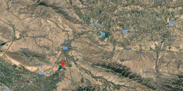
The operational production site of the G’allaorol State Forestry Enterprise – Qoravultepa Forest Section Nursery is located in G’allaorol District of Jizzakh Region, Republic of Uzbekistan.
The nursery area is situated within the semi-arid foothill and steppe transition zone of central Uzbekistan, forming part of the broader Aydar–Arnasay lake system landscape. The surrounding territory consists of a mosaic of irrigated agricultural lands, natural steppe vegetation, and degraded lands requiring ecological restoration.
According to the cadastral documentation and site maps provided by the G’allaorol State Forestry Enterprise, the nursery plots and surrounding forest fund lands are delineated within the Qoravultepa forest section, where the designated nursery production areas are integrated with protective forest plantations and restoration zones.
The operational production site of the G’allaorol State Forestry Enterprise – Qoravultepa Forest Section Nursery is located in G’allaorol District of Jizzakh Region, Republic of Uzbekistan.
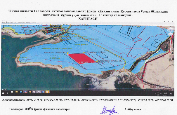
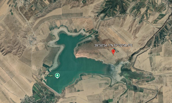
The designated nursery production area covers approximately 1.5 hectares. The site boundaries are defined by the following coordinates:
- 39°51’44.46″N, 67°32’27.48″E
- 39°51’44.46″N, 67°32’31.78″E
- 39°50’54.08″N, 67°32’58.47″E
- 39°50’52.70″N, 67°32’40.78″E
1.3.2. Distance to Major Centers
Approximate distances:
• G’allaorol district center: approximately 10–15 km from the nursery site
• Jizzakh city: approximately 60–70 km east
• Samarkand city: approximately 90–100 km southeast
• Regional highway corridor (Samarkand–Jizzakh transport route): within short driving distance
This positioning provides:
• Logistical access to district and regional administrative services;
• Efficient transportation routes for regional seedling distribution and restoration activities;
• Accessibility to agricultural irrigation networks and restoration areas in the surrounding semi-arid landscape.
1.3.3. Surrounding Settlements
Based on satellite imagery and regional mapping, the Qoravultepa forest section nursery area is surrounded by several dispersed rural settlements and agricultural production zones typical of the G’allaorol District landscape.
These settlements form part of a mixed agricultural–pastoral land-use system, characterized by irrigated crop production areas, rainfed fields, and steppe vegetation zones distributed across the foothill–plain transition of central Uzbekistan.
The presence of multiple rural settlements within a short radius indicates:
• Availability of seasonal and permanent rural labor;
• Integration within active agricultural production systems;
• Potential demand for windbreak plantations, shelterbelts, and agroforestry seedlings supporting climate adaptation and land protection measures.
1.3.4 Landscape and Agro-Ecological Context
The nursery site is located in:
• A semi-arid continental climate zone typical of central Uzbekistan;
• A mixed agricultural and steppe landscape, combining irrigated fields with rainfed land and natural vegetation;
• A gently undulating foothill–plain transition zone characteristic of the G’allaorol District area.
Key environmental characteristics include:
• Hot summers and cold winters, typical of continental climatic regimes;
• High evapotranspiration rates during the vegetation period;
• Partial dependence on irrigation systems for agricultural production;
• Exposure to wind erosion in open agricultural fields and degraded lands;
• Localized risks of soil degradation and salinization in irrigated areas.
These conditions generate structural demand for:
• Climate-resilient planting material adapted to semi-arid environments;
• Protective shelterbelt systems reducing wind erosion and improving microclimate conditions;
• Stabilization plantings along irrigation canals and field boundaries;
• Drought- and salt-tolerant tree and shrub species suitable for restoration and agroforestry systems.
1.3.5 Strategic Position within the Regional Ecological Framework
The broader region surrounding the G’allaorol District of Jizzakh Region includes various natural landscapes consisting of steppe ecosystems, foothill zones, and degraded lands targeted for ecological restoration under national afforestation programs.
Although the district contains areas of ecological importance and restoration priority within the national forestry framework, the Qoravultepa Forest Section Nursery itself does not fall within the boundaries of a designated national protected area according to currently available regional mapping.
The nursery therefore operates:
• Within a semi-arid landscape characterized by agricultural land use and steppe vegetation;
• In proximity to degraded lands and restoration zones requiring afforestation and protective plantations;
• In a transition area between agricultural production systems and forest restoration landscapes targeted by national greening initiatives.
1.3.6 Functional Implications for Nursery Development
The geographic positioning of the G’allaorol State Forestry Enterprise – Qoravultepa Forest Section Nursery offers:
• Strategic proximity to the G’allaorol district administrative center and regional transport corridors;
• Access to local rural labor markets and agricultural communities;
• Direct relevance to land degradation control, shelterbelt establishment, and restoration of semi-arid landscapes;
• Operational viability for scaling up both open-field and container-based seedling production systems.
In spatial terms, the nursery is located in a zone where ecological restoration, agricultural land protection, and climate adaptation objectives converge, reinforcing its role as a regional forestry infrastructure node within the Jizzakh Region restoration landscape.
1.4 Online Assessment and Site Evaluation Findings – G’allaorol State Forestry Enterprise – Qoravultepa Forest Section Nursery
1.4.1 Online Assessment of the G’allaorol State Forestry Enterprise – Qoravultepa Forest Section Nursery
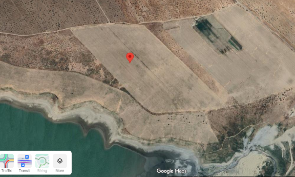
Nursery Boundary Coordinates
According to the cadastral map, the nursery plot is defined by the following approximate boundary points:
Ғаллаорол ўрмон НИХОЛХОНА
- 39°51’44.46″N, 67°32’27.48″E
- 39°51’44.46″N, 67°32’31.78″E
- 39°50’54.08″N, 67°32’58.47″E
- 39°50’52.70″N, 67°32’40.78″E
Decimal Coordinates (for Google Earth / GIS)
- 39.862350, 67.540967
- 39.862350, 67.542161
- 39.848356, 67.549575
- 39.847972, 67.544661
Approximate Central Coordinate of the Nursery Site
For mapping or reporting purposes, the following coordinate can be used as the central reference point:
39.848356, 67.549575
Direct Map Links
Google Maps / Google Earth links:
- https://www.google.com/maps?q=39.848356,67.549575
- https://earth.google.com/web/search/39.848356,67.549575
These coordinates correspond to the Qoravultepa forest section nursery area in G’allaorol District, Jizzakh Region, Uzbekistan, covering approximately 1.5 hectares as indicated in the cadastral map.
1.4.2. Observation and Strategic Assessment
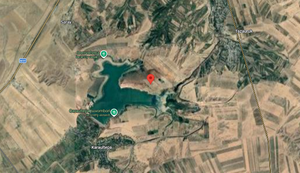
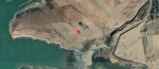
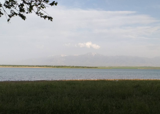
Based on the analysis of satellite imagery and spatial data corresponding to the coordinates 39°50’54.1″N, 67°32’58.5″E, the proposed nursery site of the G’allaorol State Forestry Enterprise – Qoravultepa Forest Section Nursery is located within a semi-arid agricultural–steppe transition zone in G’allaorol District, Jizzakh Region.
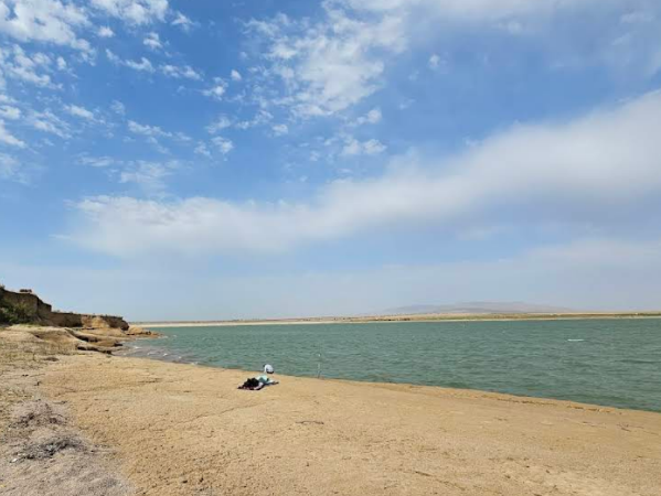
The site is situated in proximity to the Aydar–Arnasay lake system, which forms one of the largest inland water bodies in central Uzbekistan and influences the local microclimate and hydrological conditions.
The surrounding landscape is characterized by:
• Semi-arid steppe vegetation and dryland agricultural fields
• Scattered rural settlements and agricultural production areas
• Limited irrigation infrastructure associated with local farming systems
• Gently undulating terrain typical of the foothill–steppe transition of central Uzbekistan.
The proximity to the lake system and surrounding agricultural lands creates favorable conditions for the establishment of a nursery supporting:
• shelterbelt and wind-protection plantations;
• restoration of degraded steppe lands;
• agroforestry systems adapted to semi-arid climates;
• production of drought-resistant tree and shrub species suitable for landscape restoration.
In strategic terms, the nursery site is positioned within a landscape where land degradation control, agricultural protection, and climate-resilient restoration needs converge, reinforcing its potential role as a regional seedling production node under the RESILAND CA+ framework.
1.4.3 Water Resources and Hydrogeological Feasibility
The proposed nursery site, located at approximately 39°50’54.1″N, 67°32’58.5″E in G’allaorol District of Jizzakh Region, lies in close proximity to a reservoir forming part of the Aydar–Arnasay lake system. This large inland water body represents one of the most significant hydrological features of central Uzbekistan and influences local groundwater conditions and microclimatic dynamics in the surrounding landscape.
Satellite imagery indicates that the nursery area is situated near the northern shoreline of the reservoir, within a semi-arid agricultural–steppe transition zone characterized by dispersed farming areas and limited irrigation infrastructure.
Potential water sources for nursery operations may include:
• Surface water resources associated with the nearby reservoir and local irrigation canals serving surrounding agricultural lands;
• Shallow groundwater aquifers, which are commonly present in areas adjacent to large reservoirs and may be accessed through wells;
• Seasonal agricultural irrigation networks that could support supplementary water supply for seedling production.
The proximity of the reservoir may provide several operational advantages, including improved groundwater recharge potential and the possibility of establishing stable irrigation systems necessary for nursery development, particularly for container-based seedling production systems.
However, hydrogeological considerations should also include:
• Possible seasonal fluctuations in reservoir water levels;
• Localized soil salinity risks in low-lying areas near the shoreline;
• High evaporation rates typical of semi-arid continental climates.
Overall, the hydrological setting suggests that adequate water supply for nursery operations is technically feasible, provided that appropriate irrigation infrastructure, water abstraction permissions, and soil salinity management measures are incorporated into the nursery development plan.
1.4.4 Energy Infrastructure and Accessibility
The proposed nursery site, located in G’allaorol District of Jizzakh Region near the coordinates 39°50’54.1″N, 67°32’58.5″E, is situated within a rural agricultural landscape that is connected to local infrastructure networks serving nearby settlements and farming areas.
Satellite imagery and regional mapping indicate the presence of local access roads and agricultural service tracks linking the nursery area to surrounding rural settlements and to the district transport network. These routes provide practical accessibility for nursery operations, including the transportation of inputs, equipment, and produced seedlings.
The nursery site benefits from the following infrastructural conditions:
• Proximity to rural electricity distribution networks supplying nearby settlements and agricultural facilities;
• Access through local agricultural roads connecting the site with the G’allaorol district road network;
• Reasonable transport connectivity for distributing seedlings to surrounding agricultural landscapes and restoration areas;
• Potential for installation of basic operational infrastructure, including irrigation pumps, small-scale processing facilities, and container-based seedling production systems.
Given the relatively short distance to rural settlements and existing infrastructure corridors, the extension of electricity supply to nursery production facilities—such as pumping stations, irrigation systems, and nursery management structures—is considered technically feasible.
In logistical terms, the location offers sufficient accessibility to support nursery development while remaining situated within the landscape zones where restoration planting material will be required, thereby strengthening the operational relevance of the nursery within regional afforestation and land restoration programs.
1.4.5 Review of Technical Planning Documentation
As part of the feasibility assessment, the available technical and cadastral planning documentation related to the proposed nursery site within the G’allaorol State Forestry Enterprise – Qoravultepa Forest Section was reviewed. The documentation includes spatial maps and land allocation materials indicating the designated nursery production area and its boundaries.
The reviewed planning map illustrates the forest fund land within the Qoravultepa forest section of the G’allaorol State Forestry Enterprise, including the allocation of a 1.5-hectare plot designated for nursery development. The map provides detailed boundary delineation, surrounding forest management units, and the relationship between the nursery site and adjacent land parcels.
The documentation also includes geographic coordinates of the plot’s corner points, enabling precise spatial identification of the nursery site within regional mapping and satellite imagery systems. These coordinates confirm the location of the proposed nursery in proximity to the shoreline of the Aydar–Arnasay lake system, within the semi-arid landscape of G’allaorol District, Jizzakh Region.
According to the reviewed technical materials, the nursery site forms part of the forest fund land managed by the G’allaorol State Forestry Enterprise, indicating that the land is already designated for forestry-related activities and therefore suitable for nursery development within the institutional framework of the national forestry administration.
The availability of clearly defined cadastral boundaries and planning documentation provides several operational advantages:
• Legal clarity regarding land allocation and institutional ownership;
• Precise spatial definition of the nursery development area;
• Compatibility with forest management planning units of the enterprise;
• Facilitation of technical design and infrastructure planning for nursery development.
Overall, the reviewed documentation confirms that the proposed nursery area is technically identifiable, institutionally allocated, and spatially suitable for the establishment or upgrading of nursery infrastructure under the RESILAND CA+ framework.
1.5. Conclusion of First Assessment &Feasibility Report
Considering the limited size of the designated area (approximately 1.5 hectares), its proximity to nearby rural settlements, and the absence of existing nursery infrastructure, it may be recommended that the site be developed as a small-scale nursery primarily oriented toward agroforestry seedling production rather than as a large-capacity forestry nursery.
Such a configuration would allow the nursery to focus on the production of multi-purpose tree and shrub species suitable for agroforestry systems, shelterbelts, and farm-level landscape restoration, while maintaining operational feasibility within the spatial and infrastructural constraints of the site.
Within this framework, the establishment of a small-scale agroforestry-oriented nursery at the site is considered technically feasible.