Phase 4: First Assessment &Feasibility Report
Design, Upgrading, and Preparation of Nine (9) Forestry Nurseries
Uzbekistan Resilient Landscapes Restoration Project (RESILAND CA)
Report Title:
Shortan Forest Nursery
First Assessment &Feasibility Report
Prepared by:
İsmail Belen
International Consultant – Forestry Nursery Design and Preparation
Date: 6 March 2026
1. Introduction, Context and Policy Framework 4
1.1 Strategic Positioning of the Shortan/Shurtan Nursery within RESILAND CA+ 4
1.2 Alignment with the Uzbekistan–2030 Strategy and National Environmental Priorities 5
1.3 District Context: Shortan/Shurtan, Qashqadaryo Region 6
1.3.1 Geographic Location and Elevation Profile 6
1.3.2 Climate and Temperature Regime 10
1.3.4 Landform and Terrain Conditions 12
1.3.5 Water Availability and Hydrological Context 13
1.3.6 Environmental Risks and Climate Stressors 15
1.3.7 Implications for Species Selection and Nursery Typology 15
1.3.8. Integrated Technical Conclusion 16
1.4 Field Mission and Site Assessment Findings 18
1.4.1. Visit to Sho’rtan State Forestry Directorate and Proposed Nursery Area 18
1.4.2. Reviewing Shortan Nursery 19
1.4.3 Observation and Strategic Assessment 23
1.4.4 Water Resources and Hydrogeological Feasibility 23
1.4.5 Energy Infrastructure and Accessibility 24
1.4.7 Integrated Strategic Conclusion of the Field Assessment 24
1.5 Conclusion of First Assessment & Feasibility Report 25
Introduction
This First Assessment & Feasibility Report is prepared for the forest nursery of Shurtan State Forest Management (Sho‘rtan davlat o‘rmon xo‘jaligi) in line with the Technical Disposition for the Design, Upgrading, and Preparation of Forest Nurseries in Uzbekistan (RESILAND CA Nursery Framework – RNF). It has been developed as an integral component of the consultancy services under Contract No. LRP/IC/08, titled “International Consultant to Provide Technical Expertise for the Design, Upgrading, and Preparation of Nine (9) Forestry Nurseries.”
To this end, Mr. İsmail Belen, International Consultant, conducted a field mission to the Shortan Forest Nursery on 5 February 2026 and finalized the present First Assessment & Feasibility Report in full compliance with contractual obligations and in close coordination with the Agency for Forest and Green Area Expansion and Combating Desertification and the Qashqadaryo Regional Forestry Administration.
With the completion of this report, Phase 4 – Assessment & Feasibility for the Shortan Forest Nursery has been formally concluded. Subject to the approval of the RESILAND CA+ Project Implementation Unit (PIU), the project will proceed to the following implementation stages:
- Phase 5 – Nursery Design: Preparation of Detailed Nursery Designs
- Phase 6 – Technical Specifications & BoQ: Development of Technical Specifications and Bills of Quantities
- Phase 7 – Validation & Training: Second Field Mission for Validation and Capacity Building
1. Introduction, Context and Policy Framework
1.1 Strategic Positioning of the Shortan/Shurtan Nursery within RESILAND CA+
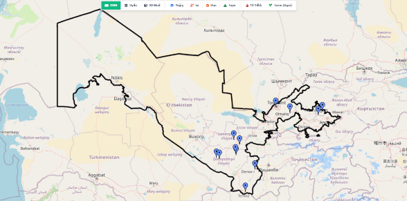
The Shurtan State Forest Management Forest Nursery (Sho‘rtan davlat o‘rmon xo‘jaligi) is one of the nine (9) priority state forestry nurseries selected under the Uzbekistan Resilient Landscapes Restoration Project (RESILAND CA+).
The inclusion of Shurtan among the nine target nurseries reflects its strategic importance in addressing a fundamental structural constraint in Uzbekistan’s restoration agenda: the insufficient and inconsistent supply of high-quality, climate-resilient planting material adapted to the semi-arid and arid ecological conditions of the Kashkadarya Region.
Under RESILAND CA+, nurseries are not treated as auxiliary facilities supporting isolated planting campaigns. They are conceived as core public production infrastructure, forming the biological and operational backbone of large-scale landscape restoration. In this context, the Shurtan Forest Nursery contributes directly to the Project Development Objective (PDO) of bringing 280,000 hectares under sustainable landscape management.
The nursery’s strategic role aligns with two core project components:
• Sub-component 1.1 – Strengthen Institutions and Policies
Supporting legal and regulatory reforms, including the Draft Forest Code, standardization of nursery operations, seed certification systems, and science-based ecological planning frameworks.
• Sub-component 2.1 – Enhance Tree-based Landscape Restoration and Management
Ensuring the production and supply of site-matched, climate-resilient planting material required for agroforestry systems, reforestation, farmer-managed natural regeneration (FNR), protective forest belts, watershed stabilization, and ecosystem service-oriented interventions.
Within the RESILAND CA+ results chain, the Shurtan Forest Nursery functions as:
• An enabling infrastructure linking national policy reform to field-level implementation;
• A risk-reduction mechanism, minimizing plantation failure rates through improved species-site matching and seedling quality control;
• A scalable production platform, supporting corridor-based and regionally differentiated restoration strategies across Kashkadarya and adjacent ecological zones.
1.2 Alignment with the Uzbekistan–2030 Strategy and National Environmental Priorities
The Uzbekistan–2030 Strategy (Presidential Decree No. UP-158, 11 September 2023) establishes binding national targets under Articles 67–71 related to afforestation, erosion control, biodiversity conservation, climate adaptation, and Aral Sea region restoration.
Key quantified national commitments include:
• Planting 200 million seedlings annually;
• Increasing green area coverage to 30%;
• Expanding forest area to 6.1 million hectares;
• Establishing 600,000 hectares of climate-protective green areas;
• Restoring 2.6 million hectares in the Aral Sea region;
• Increasing tree and shrub seed harvesting by 840 tonnes.
These targets require a permanent, technically robust nursery system capable of producing large volumes of diverse, climate-adapted planting material.
The Shurtan State Forest Management Forest Nursery (Sho‘rtan davlat o‘rmon xo‘jaligi) directly supports:
• Article 67 – “Yashil Makon” National Project expansion;
• Article 68 – Forest area expansion and protective forest establishment;
• Article 70 – Climate change adaptation and desertification control;
• Article 71 – Biodiversity conservation and medicinal plant cultivation.
The nursery therefore operationalizes national commitments by translating quantified afforestation targets into biologically viable, quality-controlled seedling production and supply systems aligned with regional ecological conditions of Kashkadarya.
1.3 District Context: Shortan/Shurtan, Qashqadaryo Region
Official administrative data were accessed in February 2026 through the Government Portal of the Republic of Uzbekistan (gov.uz). The following official sources were consulted:
- Qarshi District Administration (Qashqadaryo Region)
Qashqadaryo Viloyati Qarshi Tumani Hokimligi
https://gov.uz/oz/qarshi - Qarshi City Administration
Qarshi Shahri Hokimligi
https://gov.uz/oz/qarshish - Qashqadaryo Regional Administration
Qashqadaryo Viloyati Hokimligi
https://gov.uz/oz/qashqadaryo
1.3.1 Geographic Location and Elevation Profile
Qashqadaryo Region, Republic of Uzbekistan
Qarshi is located in the southern part of the Republic of Uzbekistan and serves as the administrative capital of Qashqadaryo Region. The city functions as a regional economic, administrative, and service hub within the broader Kashkadarya River basin system. Its geographic position in a semi-arid lowland zone shapes both its environmental conditions and development dynamics.
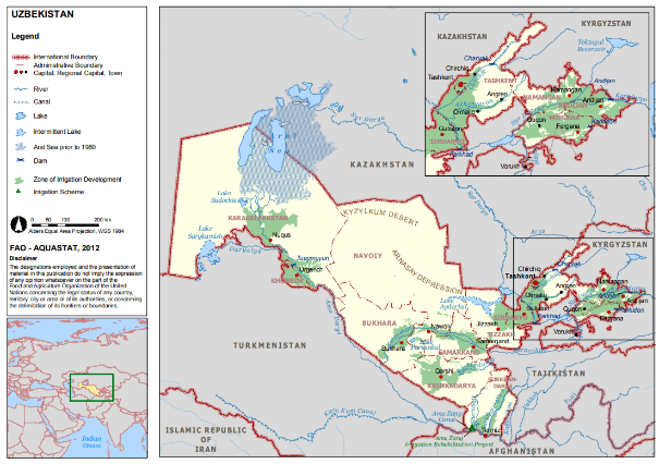
Its location within the Kashkadarya River basin places Qarshi at the center of one of Uzbekistan’s most irrigation-dependent agricultural systems. The Kashkadarya River originates in the western Pamir-Alay mountains and flows toward the Qarshi Steppe, where natural discharge is insufficient to sustain large-scale agriculture without hydraulic regulation and inter-basin water transfers. Consequently, the region relies heavily on engineered infrastructure, including reservoirs, canals, and high-lift pumping stations connected to the Amu Darya basin. This infrastructural dependence reflects broader water management dynamics in southern Uzbekistan, where irrigation underpins regional economic stability (World Bank, 2023:
https://documents1.worldbank.org/curated/en/099092023111551861/pdf/P178340055867709208353086819a2be00f.pdf).
Climatically, the region is characterized by a continental semi-arid regime, marked by hot summers, low annual precipitation, and high evapotranspiration rates. Rainfall is both limited and unevenly distributed, reinforcing the structural reliance on irrigation systems. According to FAO AQUASTAT, irrigated agriculture accounts for the vast majority of national freshwater withdrawals in Uzbekistan, with southern regions such as Kashkadarya being particularly vulnerable to seasonal variability and climate stress (FAO AQUASTAT – Uzbekistan Country Profile:
https://www.fao.org/aquastat/en/countries-and-basins/country-profiles/country/UZB).
The development of the Qarshi Steppe irrigation scheme, especially during the Soviet land reclamation period, transformed the area into a major agricultural production zone. However, intensive irrigation has contributed to persistent environmental challenges, including soil salinization, rising groundwater tables, and drainage inefficiencies. These structural problems are highlighted in irrigation modernization analyses emphasizing the need for rehabilitated drainage infrastructure, energy-efficient pumping systems, and improved water distribution management (World Bank Irrigation Modernization Project:
https://projects.worldbank.org/en/projects-operations/project-detail/P178340)
Beyond agriculture, Qarshi functions as a regional administrative, industrial, and service hub, supporting agro-processing industries, transport networks, and public administration systems. Nevertheless, the city’s long-term sustainability remains closely tied to water governance reform, energy–water efficiency integration, and climate adaptation strategies. Recent policy frameworks stress the importance of modernized irrigation infrastructure, enhanced water accounting and metering, and climate-resilient storage solutions to address growing hydrological uncertainty (World Bank Country Climate and Development Report – Uzbekistan:
https://openknowledge.worldbank.org/handle/10986/40382).
In sum, Qarshi represents a semi-arid river-basin urban system where economic growth, agricultural productivity, and environmental sustainability are structurally interdependent, and where large-scale irrigation infrastructure remains the central determinant of regional development trajectories.
Historical Background
The origins of Qarshi trace back to the ancient city of Nasaf (Nakhshab), which was an important settlement along historical Silk Road trade corridors. Following periods of destruction during the Mongol invasions, the city was reconstructed and later became known as “Qarshi,” derived from a Persian term referring to a fortified structure or palace. During the Timurid era, the settlement gained renewed regional importance.
Today, Qarshi retains elements of its historical and architectural heritage while functioning as a modern regional center.
Administrative and Demographic Profile
Qarshi serves as the administrative headquarters of Qashqadaryo Region. The city’s estimated population is approximately 260,000–300,000 inhabitants (based on recent regional statistical data, 2023–2024 period). The broader urban–peri-urban zone contributes to a higher functional population due to daily economic interaction with surrounding districts.
The demographic structure reflects national trends in Uzbekistan:
- A relatively young population profile;
- A strong labor force participation rate;
- A significant share of employment linked to agriculture, agro-processing, services, and energy-related sectors.
The city plays a coordinating role for district-level governance, public service delivery, and regional development planning.
Geographic and Environmental Context
Qarshi is situated within the lower basin of the Kashkadarya River system at an elevation of approximately 350–400 meters above sea level. The region is characterized by:
- Semi-arid continental climate conditions;
- Hot summers with high evapotranspiration rates;
- Mild to moderately cold winters;
- Low annual precipitation;
- Strong solar radiation and seasonal wind exposure.
Agricultural production in the region is heavily dependent on irrigation infrastructure connected to the Kashkadarya basin and associated reservoirs and canal systems. Water resource management is therefore a central environmental and economic factor.
The surrounding landscape consists primarily of irrigated plains, shelterbelt plantations, agricultural fields, and desert-steppe ecosystems. Soil salinity and wind erosion are relevant environmental challenges in certain areas.
Economic Structure
Qarshi functions as one of the primary agro-industrial and energy centers of southern Uzbekistan. The regional economy is structured around the following sectors:
- Irrigated agriculture (cotton, wheat, vegetables, fodder crops);
- Agro-processing and food industries;
- Textile production;
- Construction materials manufacturing;
- Natural gas infrastructure and related energy facilities (including the Qarshi–Bukhara gas corridor system).
The agricultural base of the surrounding Qashqadaryo plains plays a strategic role in national production systems, particularly for cotton and grain.
Cultural and Institutional Infrastructure
Qarshi hosts educational institutions, vocational training centers, cultural facilities, and regional administrative bodies. The presence of higher education and technical institutions contributes to workforce development and institutional capacity building.
Architectural and cultural landmarks include historical mosques and madrasas reflecting Timurid and post-Timurid influences. Traditional handicrafts, including textile and craft production, remain part of the local cultural economy.
Transport and Connectivity
Qarshi benefits from established transport connections, including:
- Rail links to Tashkent, Bukhara, and other major cities;
- Regional highway networks;
- Qarshi International Airport, facilitating domestic connectivity.
These infrastructure assets strengthen its role as a regional logistics and coordination center.
Strategic Importance
From a regional development perspective, Qarshi serves as:
- The administrative and governance center of Qashqadaryo Region;
- A hub for agro-industrial production;
- A node within Uzbekistan’s southern energy infrastructure network;
- A service and coordination center for surrounding rural districts.
Its location within a semi-arid basin system, combined with irrigation-dependent agriculture and exposure to climate variability, makes climate-resilient land management, protective forestry, and sustainable landscape restoration strategically important for long-term regional stability.
1.3.2 Climate and Temperature Regime
Qarshi City is characterized by a continental semi-arid lowland climate, typical of the lower Kashkadarya basin. Unlike mountain-influenced districts within Qashqadaryo Region, Qarshi’s climatic regime is primarily shaped by its low elevation (approximately 350–400 meters above sea level) and its open steppe landscape structure, which intensifies solar exposure and evapotranspiration dynamics.
The regional climatic norms indicate the following parameters:
- Mean annual temperature: 14–16°C
- Average July temperature: 28–32°C
- Peak summer temperatures: frequently exceed 40°C
- Average January temperature: 0°C to +3°C
- Absolute winter minima: occasionally below –15°C
Annual precipitation averages approximately 250–320 mm, reflecting typical arid to semi-arid lowland conditions. Rainfall distribution is markedly seasonal, with precipitation concentrated during:
- Late autumn
- Winter
- Early spring
Summer months are generally hot and dry, characterized by intense solar radiation, high evapotranspiration rates, low relative humidity, and prolonged heat stress periods. These climatic conditions create structural water deficits during the main vegetation period.
Given the prevailing semi-arid climatic conditions, nursery establishment and operation in Qarshi require climate-adaptive technical planning. The following considerations are critical:
- Irrigation Dependency
Nursery production is fully dependent on irrigation throughout the growing season, particularly from May to September, when natural precipitation is negligible. - Microclimate and Shade Management
Advanced shade systems (e.g., shade nets, structured microclimate control measures) are essential to protect seedlings during extreme summer temperatures exceeding 40°C. - Species Selection Strategy
Priority should be given to heat- and drought-tolerant species capable of maintaining physiological stability under high evapotranspiration stress. - Wind Protection Measures
Establishment of windbreaks is recommended to reduce moisture loss, protect young seedlings, and stabilize nursery microclimate conditions. - Production System Typology
Containerized (closed-root) production systems are strongly recommended, as they reduce transplant shock, improve water-use efficiency, and increase survival rates under high-temperature regimes. - Water-Use Efficiency Technologies
Adoption of efficient irrigation technologies—such as drip or micro-sprinkler systems—is critical to optimize water consumption and maintain uniform moisture conditions in a high-evaporation environment.
In conclusion, Qarshi’s climatic conditions impose structural water stress and heat exposure risks on nursery operations. However, with appropriate irrigation management, microclimate control, species-site matching, and modern production systems, climate constraints can be effectively mitigated, enabling sustainable and resilient nursery development within the lower Kashkadarya basin context.
1.3.3 Soil Characteristics
Soil conditions in Qarshi City and its surrounding lowland areas are primarily shaped by arid–semi-arid climatic conditions, fluvial deposition processes of the Kashkadarya basin, and decades of intensive irrigated agriculture. Unlike foothill districts such as Kitob, Qarshi is situated within a low-elevation alluvial plain system, where soil formation is closely linked to river sedimentation, irrigation return flows, and groundwater dynamics.
The dominant soil groups in the Qarshi lowland zone include sierozem (grey desert) soils, which are characteristic of arid steppe and desert–steppe environments of southern Uzbekistan. These soils typically exhibit light to medium texture (sandy loam to loam) and moderate structure, forming the principal agricultural base of the region.
(FAO AQUASTAT – Uzbekistan Country Profile:
https://www.fao.org/aquastat/en/countries-and-basins/country-profiles/country/UZB)
In irrigated agricultural zones, particularly within the Qarshi Steppe development area, alluvial and irrigated meadow-alluvial soils are common. These soils originate from fluvial sediment deposition combined with long-term irrigation practices. However, due to high evaporation rates and shallow groundwater tables in some areas, secondary salinization processes may occur.
(World Bank – Irrigation and Drainage Sector Review, Uzbekistan:
https://openknowledge.worldbank.org/handle/10986/40382)
Compared to upstream districts, Qarshi’s lowland soils are more directly influenced by irrigation return flows and basin-level water management practices, increasing their sensitivity to salinity accumulation. The presence of calcareous subsoil horizons is typical, which may affect nutrient mobility—particularly phosphorus availability—and root penetration depth. Soil organic matter content is generally low to moderate, reflecting arid climatic constraints and intensive cultivation patterns.
Drainage conditions vary significantly depending on irrigation efficiency. In well-managed parcels, drainage is moderate; however, in areas with insufficient drainage infrastructure, waterlogging and salt accumulation risks increase, especially under traditional flood irrigation systems.
(World Bank – Modernization of Irrigation Infrastructure in Uzbekistan:
https://projects.worldbank.org/en/projects-operations/project-detail/P178340)
Several structural soil-related risks must therefore be acknowledged in Qarshi:
- Soil salinity and sodicity risk, particularly in poorly drained irrigated fields;
- Surface crust formation under high evaporation and flood irrigation regimes;
- Wind erosion susceptibility, due to open steppe conditions and sparse vegetative cover;
- Progressive nutrient depletion, especially nitrogen and micronutrients, under continuous cultivation without systematic soil management.
For nursery development and modernization in Qarshi, soil management must be treated as a critical design parameter from the outset. The following measures are recommended:
- Comprehensive soil testing prior to site finalization, including pH, electrical conductivity (EC), sodium adsorption ratio (SAR), nutrient profile, texture, and infiltration rate analysis;
- Water quality testing, particularly salinity and mineral content, to assess irrigation suitability;
- Organic matter enhancement programs, including structured composting systems to improve soil structure and moisture retention;
- Raised-bed or container-based production systems, reducing direct exposure to saline or structurally variable soils;
- Engineered drainage design, preventing localized waterlogging and secondary salinization;
- Windbreak establishment, mitigating erosion and evapotranspiration stress.
Given Qarshi’s position within the lower Kashkadarya basin and its fully irrigation-dependent agricultural system, salinity management and water-use efficiency are central determinants of soil sustainability. With appropriate testing, substrate management, and modern irrigation design, nursery production systems can be aligned with local edaphic constraints while maintaining long-term soil productivity under intensified use.
1.3.4 Landform and Terrain Conditions
The terrain of Qarshi City and its surrounding areas is defined by lowland alluvial plains within the lower Kashkadarya River basin, forming part of the broader Qarshi Steppe landscape. Unlike foothill districts such as Kitob, Qarshi is characterized by predominantly flat terrain shaped by fluvial and irrigation-related sediment deposition processes.
(FAO AQUASTAT – Uzbekistan Country Profile:
https://www.fao.org/aquastat/en/countries-and-basins/country-profiles/country/UZB)
The dominant landform characteristics include:
- Extensive flat to nearly flat alluvial plains;
- Artificially leveled agricultural fields developed under irrigation schemes;
- Irrigation and drainage canal networks integrated into the landscape;
- Desert–steppe transitional zones in peripheral areas.
According to regional land and irrigation development documentation, the Qarshi Steppe was extensively transformed through large-scale irrigation expansion during the Soviet period, resulting in a highly engineered lowland agricultural terrain.
(World Bank – Irrigation Modernization and Sector Review, Uzbekistan:
https://projects.worldbank.org/en/projects-operations/project-detail/P178340)
Slope gradients in the Qarshi lowland zone are generally minimal:
- 0–2% across most irrigated plains;
- Local micro-relief variations associated with canal embankments and drainage structures;
- No significant natural slope gradients comparable to foothill or mountainous districts.
These low gradients have important operational implications. While flat terrain facilitates large-scale mechanized agriculture and nursery layout planning, it also increases reliance on engineered drainage systems to prevent waterlogging and salinity accumulation.
(World Bank – Country Climate and Development Report: Uzbekistan:
https://openknowledge.worldbank.org/handle/10986/40382)
For nursery establishment in Qarshi’s lowland environment, terrain conditions provide:
- Favorable surface conditions for structured layout planning and mechanization;
- Ease of irrigation network installation due to minimal elevation differences;
- Operational feasibility for phased spatial expansion;
- However, high dependence on properly designed drainage systems due to limited natural runoff gradients.
Wind exposure in the open steppe landscape is generally moderate to high, particularly during dry seasons. Given the absence of natural topographic barriers, windbreak establishment is strongly recommended to reduce evapotranspiration losses, protect young seedlings, and improve microclimatic stability.
(FAO – Climate and land management guidance for arid regions:
https://www.fao.org/climate-smart-agriculture/en/)
In summary, Qarshi’s terrain is defined by flat, engineered alluvial plains with minimal natural slope gradients, offering operational advantages for nursery infrastructure development, while simultaneously requiring careful drainage planning and wind protection measures to mitigate lowland salinity and evapotranspiration risks.
1.3.5 Water Availability and Hydrological Context
The hydrological regime of Qarshi City is shaped by its location within the lower Kashkadarya River basin, operating under a predominantly irrigation-dependent lowland system. Unlike upstream districts influenced by direct mountain runoff from the Pamir–Alay system, Qarshi’s water availability is largely determined by regulated river flows, reservoir operations, inter-district water transfers, and engineered canal and pumping infrastructure.
According to FAO AQUASTAT, Uzbekistan’s southern regions—including Qashqadaryo—exhibit very high irrigation dependency, with agriculture accounting for the overwhelming majority of total freshwater withdrawals.
FAO AQUASTAT – Uzbekistan Country Profile:
https://www.fao.org/aquastat/en/countries-and-basins/country-profiles/country/UZB
Within the Qarshi Steppe development zone, historical agricultural expansion relied heavily on large-scale canal construction and pumped irrigation schemes, fundamentally altering the natural hydrological regime. World Bank irrigation modernization documentation confirms that water supply reliability in such lowland systems is highly dependent on infrastructure functionality, pumping energy availability, and seasonal allocation management.
World Bank – Irrigation Modernization Project, Uzbekistan:
https://projects.worldbank.org/en/projects-operations/project-detail/P178340
Unlike upstream foothill districts, Qarshi is more directly exposed to:
- Downstream irrigation return flows;
- Shallow groundwater fluctuations;
- Evaporation-driven salinity accumulation risks.
The World Bank’s Country Climate and Development Report for Uzbekistan highlights that lowland irrigated plains in southern Uzbekistan face growing stress from water scarcity, rising temperatures, and increasing evapotranspiration rates, all of which intensify hydrological vulnerability.
World Bank – Country Climate and Development Report: Uzbekistan:
https://openknowledge.worldbank.org/handle/10986/40382
As a result:
- Groundwater tables may fluctuate seasonally, influenced by irrigation return flows and canal seepage;
- Salinity risk is structurally higher than in upstream districts;
- Water quality may vary depending on basin-level allocation and return-flow concentration;
- Summer water supply reliability is sensitive to peak agricultural demand and energy availability for pumping systems.
Implications for Nursery Development in Qarshi
For nursery establishment in a fully irrigation-dependent lowland basin, hydrological planning must prioritize infrastructure resilience, water-use efficiency, and systematic quality control, rather than relying solely on nominal water availability figures.
Key technical considerations include:
- Verification of water source reliability, including canal flow stability and borehole feasibility assessments;
- Assessment of sustainable groundwater abstraction rates, particularly in shallow aquifer zones;
- Installation of irrigation storage reservoirs or buffering ponds to mitigate seasonal allocation variability;
- Adoption of high-efficiency irrigation technologies (drip or micro-sprinkler systems) to reduce evaporative losses under high-temperature conditions;
- Implementation of systematic water quality monitoring protocols, including electrical conductivity (EC), pH, total dissolved solids (TDS), and mineral content analysis;
- Integration of engineered drainage management systems to prevent secondary salinization and localized waterlogging within nursery compartments.
In conclusion, Qarshi’s hydrological environment is defined by engineered water dependency, elevated salinity exposure, and climate-amplified evapotranspiration stress. Sustainable nursery development therefore requires integrated water management planning, continuous monitoring, and infrastructure modernization aligned with basin-level hydrological realities.
1.3.6 Environmental Risks and Climate Stressors
Key environmental pressures in Qarshi City and its surrounding lowland areas differ from foothill districts and are primarily linked to semi-arid lowland conditions and irrigation-dependent land use systems. The dominant environmental stressors include:
- Soil salinization and secondary salinity accumulation in irrigated agricultural lands
- Waterlogging in poorly drained parcels, particularly under traditional flood irrigation systems
- Wind erosion across open steppe landscapes, especially where vegetative cover is limited
- Increasing drought intensity and prolonged dry periods, amplifying irrigation dependency
- Extreme summer heat stress, with temperatures frequently exceeding 40°C
- Pressure on water resources due to high agricultural withdrawals and infrastructure inefficiencies
These environmental dynamics generate structural demand for:
- Salt-tolerant and drought-resistant tree species adapted to lowland semi-arid conditions
- Protective shelterbelt systems to reduce wind erosion and evapotranspiration losses
- Drainage-supported afforestation models in salinity-prone areas
- Agroforestry integration within irrigated farming systems to enhance microclimate regulation and soil stability
- Rehabilitation of degraded irrigated lands through soil-improving species and phytoremediation approaches
- Climate-resilient urban and peri-urban green infrastructure development to mitigate heat stress effects
In the context of Qarshi’s lowland basin setting, environmental management priorities are therefore centered on salinity control, wind protection, water-use efficiency, and heat-resilient landscape design, rather than slope stabilization or mountain watershed restoration.
1.3.7 Implications for Species Selection and Nursery Typology
Given the semi-arid lowland conditions and the irrigation-dependent agricultural environment of Qarshi, nursery production should prioritize species and systems adapted to heat stress, salinity risk, and high evapotranspiration rates.
Nursery production in Qarshi should therefore prioritize:
- Heat- and drought-tolerant species capable of maintaining growth under prolonged summer temperatures exceeding 40°C
- Salt-tolerant species suitable for salinity-prone irrigated soils
- Wind-resistant species adapted to open steppe conditions
- Fast-growing shelterbelt species for agricultural wind protection
- Multipurpose agroforestry-compatible stock integrating economic and ecological functions within irrigated farming systems
Given the lower elevation and minimal frost severity compared to foothill districts, frost tolerance remains relevant but is not the primary limiting factor; instead, heat resilience and water-use efficiency are central selection criteria.
Nursery production systems in Qarshi should integrate:
- Structured open-field seedbeds for hardy, salt- and drought-tolerant species
- Containerized (closed-root) production blocks to improve survival under high-temperature and water-stress conditions
- Hardening zones designed to acclimatize seedlings to intense solar radiation and dry atmospheric conditions prior to outplanting
- Efficient irrigation systems (preferably drip or micro-sprinkler) to reduce evaporative losses
- Composting and substrate preparation units to enhance soil structure and mitigate salinity effects
- Windbreak installations within nursery compartments to stabilize microclimatic conditions
In Qarshi’s lowland basin context, nursery design must therefore emphasize salinity management, heat resilience, water-use efficiency, and wind protection, ensuring alignment with the environmental realities of irrigated semi-arid plains.
1.3.8. Integrated Technical Conclusion
Qarshi City presents a technically feasible but environmentally constrained lowland environment for forest nursery establishment. Its biophysical context is shaped by its location in the lower Kashkadarya basin, characterized by semi-arid climatic conditions and irrigation-dependent land use systems.
According to FAO AQUASTAT, southern Uzbekistan—including Qashqadaryo Region—falls within a high irrigation-dependency zone, where agriculture accounts for the overwhelming majority of freshwater withdrawals.
FAO AQUASTAT – Uzbekistan Country Profile:
https://www.fao.org/aquastat/en/countries-and-basins/country-profiles/country/UZB
Climatically, the World Bank’s Country Climate and Development Report for Uzbekistan highlights that southern lowland regions are exposed to:
- Increasing temperatures;
- Rising evapotranspiration rates;
- Growing seasonal water stress;
- Heightened salinity risk in irrigated plains.
World Bank – Country Climate and Development Report (Uzbekistan):
https://openknowledge.worldbank.org/handle/10986/40382
The Qarshi Steppe irrigation system historically relied on large-scale canal and pumping infrastructure, fundamentally shaping current hydrological and soil conditions.
World Bank – Irrigation Modernization Project (Uzbekistan):
https://projects.worldbank.org/en/projects-operations/project-detail/P178340
Based on these verified sources, Qarshi’s biophysical characteristics include:
- Low elevation (~350–400 m a.s.l.) within an alluvial plain system;
- Low annual precipitation (~250–320 mm) typical of semi-arid lowlands (FAO AQUASTAT);
- Extreme summer temperatures frequently exceeding 40°C (World Bank CCDR);
- High evapotranspiration and full irrigation dependency;
- Alluvial and irrigated soils with elevated salinity exposure risk (World Bank irrigation assessments);
- Flat terrain suitable for structured infrastructure development and mechanized nursery layout planning;
- Higher salinity and drainage vulnerability compared to upstream foothill districts.
From a technical perspective, Qarshi provides operational advantages in terrain uniformity and accessibility, yet requires strengthened engineering safeguards to ensure climatic resilience.
According to World Bank irrigation modernization analysis, infrastructure performance and drainage quality are decisive in maintaining soil productivity and preventing secondary salinization in lowland basins.
https://projects.worldbank.org/en/projects-operations/project-detail/P178340
Therefore, nursery establishment in Qarshi should incorporate:
- High-efficiency irrigation systems (drip or micro-sprinkler) to optimize water use under high evaporation conditions;
- Engineered drainage systems to mitigate salinity and waterlogging risks;
- Systematic soil testing and organic matter enhancement programs;
- Microclimate control measures, including shade systems and windbreaks;
- Continuous water quality monitoring (EC, pH, mineral content);
- Species-site matching, prioritizing heat-, drought-, and salt-tolerant species adapted to semi-arid irrigated plains.
Based on FAO and World Bank assessments, Qarshi’s lower-basin environment is characterized by structural irrigation dependency, increasing climate stress, and salinity exposure risk. However, with properly engineered irrigation, drainage, and microclimate control systems, the area is technically suitable for climate-smart nursery development aligned with international best practice and RESILAND CA+ restoration objectives.
The key determinants of long-term success in Qarshi are:
- Water-use efficiency
- Salinity control
- Infrastructure reliability
- Climate-resilient species selection
Thus, while more environmentally demanding than foothill districts, Qarshi remains a viable location for nursery establishment under a modernized, resilience-oriented design framework.
1.4 Field Mission and Site Assessment Findings
1.4.1. Visit to Sho’rtan State Forestry Directorate and Proposed Nursery Area
On Thursday, 5 February 2026, in the afternoon, the delegation visited the Sho’rtan State Forestry Directorate in the Qashqadaryo Region within the scope of the RESILAND field mission. The visit aimed to assess the planned establishment and improvement of a forest nursery and to review the technical documentation prepared by the Directorate.
The delegation met with Maqsud Axmedov, Director of Sho’rtan State Forestry. During the meeting, Mr. Axmedov provided detailed information on the planned nursery, including its location, size, functional design, species composition, and implementation approach.
Mr. Maqsud Axmedov – Director, Sho’rtan State Forestry. Mobile: +998 91 321 10 50
The discussion was supported by officially prepared and signed documents, including a detailed nursery layout plan (DUX 5.0) and species lists.


1.4.2. Reviewing Shortan Nursery
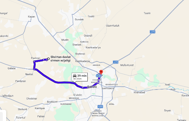
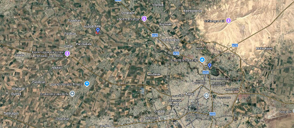
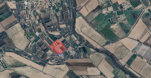
The proposed Shortan (Sho‘rtan) Forest Nursery site is located at approximately 38.933261° N latitude and 65.641772° E longitude, within the rural agricultural belt northeast of Qarshi City, Qashqadaryo Region, Republic of Uzbekistan. The site lies at an average elevation of approximately 358 meters above sea level and covers an area of approximately 9.6 hectares (96,385 m²).
The administrative headquarters of the Shortan Forestry Directorate is located at approximately 38.8903° N latitude and 65.8153° E longitude, at an elevation of approximately 370 meters above sea level. The straight-line distance between the proposed nursery site and the Directorate building is approximately 15–16 km, with an estimated road distance of approximately 18–22 km, depending on the selected route. This spatial separation remains operationally manageable and allows effective administrative supervision while maintaining decentralized production capacity.
The nursery site is positioned approximately 10–12 km northeast of Qarshi City, ensuring access to labor markets, transport infrastructure, and regional services. The surrounding landscape consists of dispersed rural settlements and agricultural mahallas within the Sho‘rtan zone. This settlement configuration provides:
- Access to seasonal and permanent workforce;
- Established rural road connectivity;
- Compatibility with agricultural land-use systems;
- Sufficient buffer from dense urban development.
From a geomorphological perspective, the site is situated within the lower Kashkadarya River basin, characterized by flat to very gently sloping terrain (approximately 0–2%). This topographic condition is highly favorable for mechanized nursery operations, block subdivision, irrigation network installation, and phased expansion.
Hydrologically, the site lies within a regulated irrigation landscape supported by canal systems connected to the Kashkadarya basin. Surrounding agricultural parcels are served by irrigation and drainage canals, and the broader hydrological network includes tributary systems such as the G‘ishmon River (G‘ishmon daryosi). The proximity to established surface water infrastructure strengthens irrigation feasibility, particularly during peak summer demand in semi-arid conditions.
However, as the site is located within a lowland irrigated plain, several hydrogeological considerations apply:
- Seasonal groundwater table fluctuations;
- Elevated evapotranspiration during summer months;
- Structural risk of secondary salinization under inadequate drainage conditions.
Overall, the spatial relationship between the nursery site, Qarshi City, and the Shortan Forestry Directorate building supports effective administrative coordination, logistical accessibility, and operational feasibility. The integration within an irrigation-supported agricultural matrix enhances water supply potential, while flat terrain facilitates infrastructure development. Long-term sustainability will depend on irrigation efficiency, engineered drainage solutions, and continuous salinity monitoring within the lowland basin environment.
The nursery is positioned within the lower Kashkadarya basin, in a predominantly irrigated agricultural landscape. The terrain is flat to very gently sloping (approximately 0–2% gradient), which significantly reduces earthwork requirements and supports:
- Mechanized nursery operations
- Structured block subdivision
- Linear irrigation system installation
- Future phased expansion
The site is located approximately 10–12 km from Qarshi city center, providing logistical accessibility while maintaining sufficient separation from dense urban development.
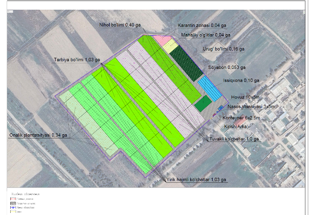
According to the officially approved DUX 5.0 layout plan, the nursery is designed as an integrated production facility consisting of clearly defined functional components:
Production Areas
- Training and hardening blocks (Tarbiya bo‘limi): 1.03 ha
- Large-size planting stock (Yirik hajmli ko‘chatlar): 1.03 ha
- Containerized seedlings (Tuvakli ko‘chatlar): 1.00 ha
- Seedling beds (Nihol bo‘limi): 0.40 ha
- Mother plantation (Onalik plantatsiyasi): 0.34 ha
Propagation and Controlled Production
- Greenhouse (Issiqxona): 0.10 ha
- Shade structures (Soyabon): 0.053 ha
- Seed section (Urug‘ bo‘limi): 0.16 ha
Biosecurity and Input Areas
- Quarantine zone (Karantin zonasi): 0.04 ha
- Compost and fertilizer preparation area (Mahalliy o‘g‘itlar): 0.04 ha
Infrastructure
- Water reservoir (10 × 5 m)
- Pump station (3 × 3 m)
- Service container (6 × 2.5 m)
- Entrance gate
The zoning structure reflects a coherent production flow from seed handling to hardened planting stock, consistent with modern nursery management principles.
1.4.3 Observation and Strategic Assessment
Field observations and geospatial verification confirm that the site presents favorable physical and operational conditions. The flat terrain and consolidated land parcel enhance efficiency and reduce development complexity.
The surrounding landscape consists of irrigated agricultural fields and dispersed rural settlements, including peripheral mahallas between Sho‘rtan and Qarshi. This configuration provides:
- Reliable local labor availability
- Established agricultural road access
- Compatibility with irrigation infrastructure
- Sufficient spatial buffer from dense residential areas
The species portfolio presented by the Forestry Directorate includes coniferous, broadleaved, ornamental, and shrub species suitable for:
- Afforestation and reforestation
- Shelterbelt establishment
- Urban landscaping
- Climate adaptation and land restoration
Strategically, the nursery aligns with national afforestation and land restoration priorities. However, modernization priorities remain necessary, particularly in irrigation efficiency, drainage engineering, and climate-control scaling.
1.4.4 Water Resources and Hydrogeological Feasibility
The nursery site is located within the lower Kashkadarya basin, a region characterized by high irrigation dependency. According to FAO AQUASTAT, agriculture accounts for the dominant share of freshwater withdrawals in Uzbekistan, particularly in southern lowland regions.
Source:
https://www.fao.org/aquastat/en/countries-and-basins/country-profiles/country/UZB
Water availability in the project area is primarily derived from regulated canal systems connected to the Kashkadarya River basin. The presence of agricultural irrigation canals and a nearby surface water network, including the G‘ishmon River system, supports irrigation feasibility.
World Bank irrigation modernization assessments confirm that water delivery reliability in such systems depends on infrastructure performance, seasonal allocation management, and energy availability for pumping.
Source:
https://projects.worldbank.org/en/projects-operations/project-detail/P178340
Hydrogeological characteristics of southern irrigated plains include:
- Seasonal groundwater table fluctuations
- Structural salinity risk
- Evaporation-driven salt accumulation
The World Bank Country Climate and Development Report highlights increasing temperature trends and evapotranspiration stress in southern Uzbekistan, intensifying irrigation demand.
Source:
https://openknowledge.worldbank.org/handle/10986/40382
Given these conditions, sustainable nursery operation will require:
- High-efficiency irrigation systems (preferably drip or micro-sprinkler)
- Engineered drainage infrastructure
- Continuous water quality monitoring (electrical conductivity, pH, salinity)
- Verification of reservoir storage capacity relative to peak seasonal demand
Hydrologically, the site is feasible provided that modern irrigation and drainage systems are incorporated into detailed design.
1.4.5 Energy Infrastructure and Accessibility
The nursery site benefits from established energy and transport infrastructure typical of irrigated agricultural zones.
Electricity supply is available in the surrounding rural area, enabling operation of pump stations, greenhouse systems, and service facilities. However, irrigation pumping introduces operational dependency on stable energy supply.
Accessibility is facilitated by:
- Proximity (10–12 km) to Qarshi City
- Rural road connections to regional transport corridors
- Flat terrain enabling year-round vehicular access
No significant geographical or infrastructural barriers to development were identified.
1.4.7 Integrated Strategic Conclusion of the Field Assessment
The integrated field assessment confirms that the proposed Shortan Nursery site demonstrates strong technical and operational potential across biophysical, institutional, and structural dimensions.
From a biophysical perspective, the site benefits from flat, mechanization-ready terrain with minimal slope constraints, facilitating efficient land preparation, infrastructure installation, and operational logistics. The total land allocation of approximately 9.6 hectares provides sufficient capacity for phased development and production scaling. Furthermore, the nursery is embedded within an established irrigated agricultural landscape, ensuring compatibility with regional land use patterns and access to irrigation infrastructure.
From an institutional and structural standpoint, the project demonstrates a high level of readiness. The existence of an officially approved and structured layout plan provides a clear spatial and operational framework. Production zoning is well defined, separating seedling beds, container production areas, training blocks, and large-size planting stock compartments. The diversified species portfolio supports afforestation, shelterbelt establishment, and urban greening objectives. Additionally, the inclusion of a mother plantation strengthens internal propagation capacity and reduces reliance on external seed sources, thereby enhancing operational autonomy.
Despite these strengths, several environmental and climate-related constraints must be acknowledged. The site is located within a semi-arid lowland zone characterized by high summer temperatures and elevated evapotranspiration rates. Nursery operations are fully dependent on irrigation, reflecting the structural water dependency of the lower Kashkadarya basin. Moreover, the lowland irrigated setting presents an inherent risk of secondary salinization, particularly under inadequate drainage or inefficient irrigation practices.
Overall, the site is assessed as technically viable and strategically justified. However, long-term sustainability and climate resilience will depend on the implementation of targeted engineering and management measures, including:
- Optimization of irrigation efficiency through modern water-saving technologies;
- Integration of engineered drainage systems to mitigate salinity and waterlogging risks;
- Verification and, if necessary, scaling of water storage capacity relative to peak seasonal demand;
- Expansion and strengthening of climate-control infrastructure, including shading systems and microclimate management components.
Provided that these measures are incorporated during the detailed design and implementation phases, the Shortan Nursery has the potential to operate as a climate-resilient and technically robust production facility aligned with contemporary nursery development standards.
1.5 Conclusion of First Assessment & Feasibility Report
The First Assessment & Feasibility evaluation confirms that the proposed Shortan Forest Nursery is geographically suitable, structurally organized, and strategically aligned with regional afforestation and climate adaptation objectives.
No fundamental environmental, institutional, or logistical constraints were identified that would preclude development.
Nevertheless, successful implementation requires:
- Detailed hydraulic and irrigation system design
- Engineered drainage solutions
- Water storage adequacy analysis
- Integrated salinity management
- Climate-resilient production planning
Subject to these technical refinements in subsequent phases, the Shortan Nursery is assessed as technically feasible, expandable, and aligned with international best practice standards for climate-smart nursery development in semi-arid irrigated environments.


")
")

")
")

")
")


